The Exact Dead Center of the City of Jerusalem Is 666
LATITUDE & LONGITUDE
 Latitude
is shown as a horizontal line and is the angular distance, in degrees,
minutes, and seconds of a point north or south of the Equator. Lines of
latitude are often referred to as parallels.
Longitude is shown as
a vertical line and is the angular distance, in degrees,
minutes, and seconds,
of a point east or west of the Prime (Greenwich) Meridian. Lines of
longitude are often referred to as meridians.
 Distance between
Lines If you divide the circumference of the earth (approximately
25,000 miles) by 360 degrees, the distance on the earth's surface
for each
one degree of latitude or longitude is just over 69 miles, or 111 km. Distance between
Lines If you divide the circumference of the earth (approximately
25,000 miles) by 360 degrees, the distance on the earth's surface
for each
one degree of latitude or longitude is just over 69 miles, or 111 km.
 Minutes and
Seconds For precision purposes, degrees of longitude and latitude have
been divided into minutes (') and seconds ("). There are 60 minutes in each
degree. Each minute is divided into 60 seconds. Seconds can be further
divided
into tenths, hundredths, or even thousandths. Minutes and
Seconds For precision purposes, degrees of longitude and latitude have
been divided into minutes (') and seconds ("). There are 60 minutes in each
degree. Each minute is divided into 60 seconds. Seconds can be further
divided
into tenths, hundredths, or even thousandths.
The exact center of the city of
Jerusalem (Yerushalayim) is 31° 47' 00 N by 35° 13' 00
E. If we add the numbers we get:
31° 47' 00 N
+35° 13' 00 E
----------------
6 6 6 . 00
This, of course, may simply be a coincidence, but the
probability of this happening is over 99,999,999 to one. You can check to location
yourself at:
MapQuest
: Latitude/Longitude Map Search
|
In Solomon's Power Brokers, by Freemasons
Knight and Butler, wherein the authors describe "Solomon's New
World Order", we read:
"The location of Jerusalem is no accident, because it is
an ideal place to observe sunrises and sunsets. The angle
of shadows cast by the rising and setting sun vary by
longitude. At the equator, every day is more or less
equally divided into light and dark and the Sun rises due
east and sets due west. At the poles, the Sun never sets
in Summer and never rises in Winter. In between these
extremes, the angle between the two solstices increases
the further one travels away from the equator. The
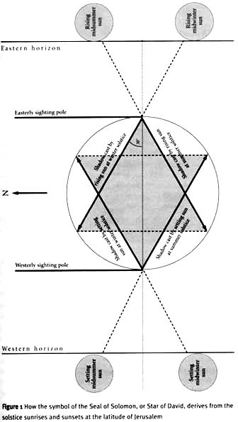
latitude of Jerusalem is 31 degrees 47' north, which means
that the angle of the shadows cast by the winter and
summer solstices is precisely 60 degrees.
To observe this, all that was necessary was to draw a
circle on the ground and place a vertical stick in the
east and another on the other side on the west.
On the morning of the winter solstice the easterly stick
would cast a shadow 30 degrees north of center and that
evening the westerly stick would cast a shadow 30 degrees
south of west.
On the morning of the winter solstice the easterly stick
would cast a shadow 30 degrees north of center and that
evening the westerly stick would cast a shadow 30 degrees
 south of west. The reverse would be the case at the summer
solstice, creating a diamond shape inside the circle. A
north-south line accross both angles produces a signature
that is unique to this latitude--and at Jerusalem it forms
a perfect six-pointed star that is known as either the
Seal of Solomon or the Star of David.
So, the symbol that has recently become the emblem of
Judaism and of the modern state of Israel is a solar
diagram that celebrates the remarkable geographical
position that the city of Jerusalem occupies.
Hiram Abif would have understood this perfectly well,
because Jerusalem had been a famous place of worship for
this very reason since the Stone Age. But his interest was
in more than just the basic sunrise and sunset patterns.
The name 'Jerusalem' in the Cannanite language means
'foundation for observing Venus rising', and Hiram wanted
to calculate the movements of Venus and of the highly
complex patterns of the Shekinah as it rises ahead of the
Sun."
(Knight, Christopher, "Solomon's Power Brokers", page 13)


VISIT TALMUDUNMASKED.COM FOR MORE INFORMATION
| CONTENTS | BIBLE | AUDIO | VIDEO | IMAGE | LINKS | BOOKS | ALERT |
|